
As soon as I stepped onto the path for Finnskogleden, I could feel the cool air of the forest. The sun was just starting to peek over the trees in the early morning. The path spread out in front of me and led to a peaceful and beautiful nature world. Old, rough-hewn houses are spread out along this trail. Which can take your mind back to the past and how things were for the people who came here to start over.
Exploring Finnskogleden
There is a hiking trail called Finnskogleden, which is also called the Finnish Forest Trail. It goes through forests in both Norway and Sweden. The trail is more than 240 kilometers (149 mi.) long and lets hikers experience the forest while learning about the traditions of the Finnish people who lived in the area in the past.
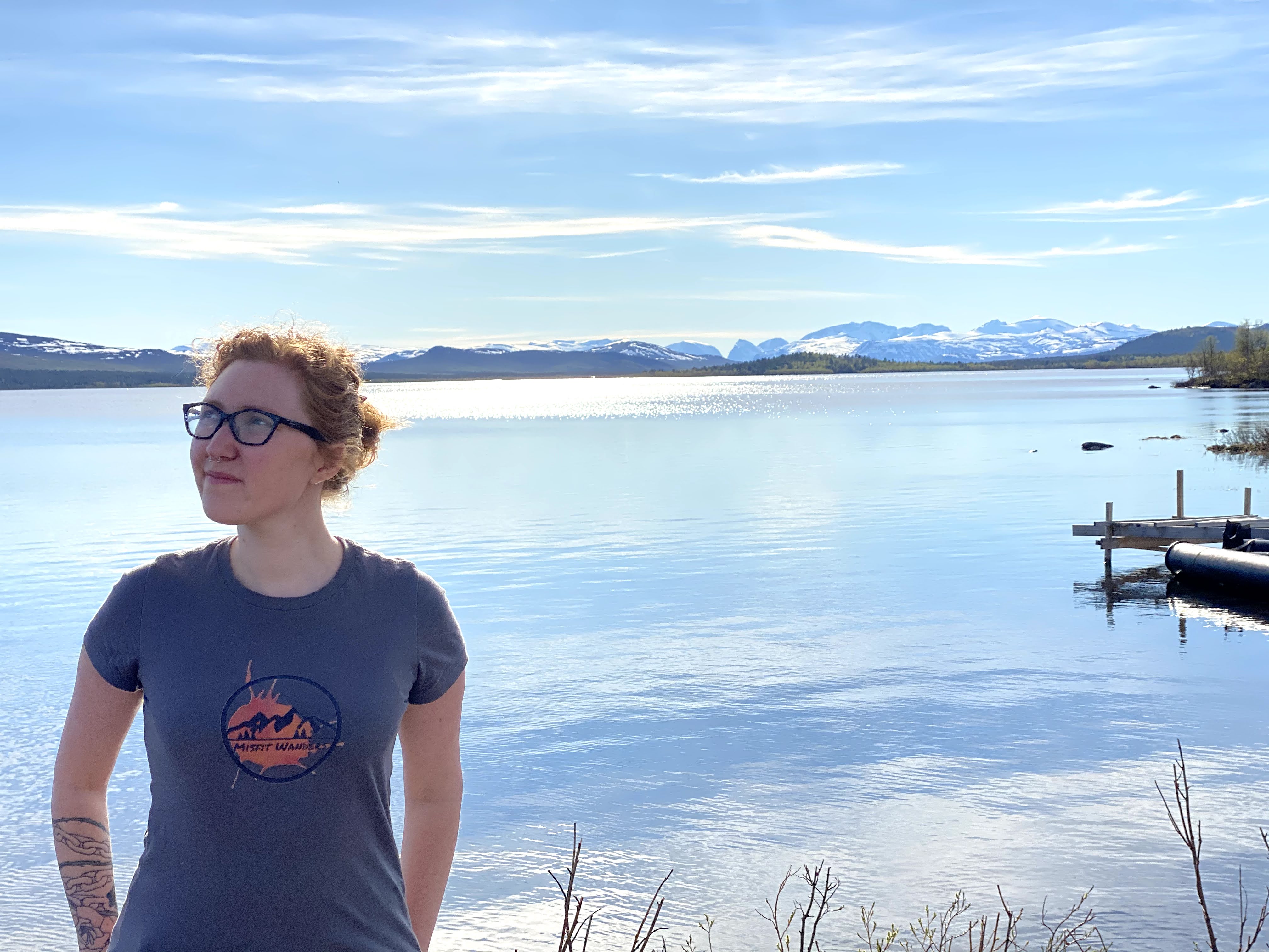
One unique thing about Finnskogleden is that hikers can choose from a number of different tracks that range in length and difficulty. Long-distance trails make up the main trail, which runs the whole length of Finnskogleden. On the other hand, there are other tracks that are shorter and easier to handle. I went on one of the walks with my husband, our friend, and our dogs. It took us a few hours. There was still some snow on the walk. We didn’t let that stop us from going out on the walk and enjoying the nature. We went by an old wooden house in one area that had a view of the lake and the trees that could not be beat. This trail starts in Sweden and goes straight to the border with Norway.
The Trails
Finnskogleden’s main trail is a huge 240 kilometers (149 mi.) long, and it can take several days to finish. The trail is difficult, with some steep climbs and descents, but the views are amazing. One bad thing about this road is that hikers who want to use it need to be very fit. You need to remember to bring all of your stuff with you when you go on this long trail. It can get very tiring to carry such a load. So, try to bring only the things you need! Forests, hills, lakes, and other natural features can be seen by hikers. They may also come across traditional Finnish buildings like log houses and saunas.
There are a number of loops and side trails that lead off from the main road for people who want to go on shorter hikes. The trails are between 4 and 18 kilometers (2.5 to 11 mi.) long, and they let you see the beauty of Finnskogleden without having to go on a longer walk. For one thing, these tracks aren’t as hard, but you should still be in good shape to be able to do them.
Here’s a breakdown of each part of the long trail:
Stage 1
From Morokulien to Håvilsrud – Difficulty: Easy – Distance: 14.2km (8.8 mi.) – Duration: Approx. 5-7 hours one way
Along Rågsroys 67, behind the peace monument, this is where the Finnskogleden starts. As you walk northwest toward the Veksla river, the path changes into a dirt road. After going over a bridge, you’ll be back on a dirt road that leads to Breitjenn. You can cool off in the water here. After taking a break, you should walk near Grensegata to get to Sweden. Finally, cross a forest hill and arrive at Håvilsrud. Any ponds you come across along this path will let you fill up your water bottle. If you really want to do the whole trail, you should definitely bring enough food to last until day 6. There are no grocery shops on or near this part of the trail.
Accomodations:
At this point, you can spend the night at Gapahuk, which is close to Jossealven and has a stove. Ronja Gård is 1 km (.6 mi.) north along county road 361 and has a bed & breakfast and cabins.
Bed & Breakfast and Cabins: (+47)902 52 309
Campsite with Cabins: (+46)703 520 699
Stage 2
It’s not too hard to get from Håvilsrud to Mitandersfors. – It’s 17.6 km (10.9 mi) away. – It takes about 5 to 8 hours one way
Lots of well-known Norwegian war heroes have used this part of the road. So, people who are interested in history would love to walk this path. A dirt road leads to the beginning for 2 km (1.2 mi). After that is done, it changes into a flat forest area that leads to Vangen. Senders used this road a lot during the Second World War. This path was used by Gunnar Sonsteby, who is the most famous war hero. Over the pine bogs, it stays pretty flat until Skålsjon. At this point, the trail goes over a river on an old dam that floats on water. There is a gapahuk on the edge of the beach. After that, the road starts to go up, and to the north, you can see Varaldsjon in a beautiful way.
Have your water bottles full before you start this walk. This part has very little to no water.
Accommodations:
There is a gapahuk with a stove by Skålsjon where you can sleep. Or, there are a few places along the road south of Mitandersfors where you can rent rooms. Two kilometers (1.2 mi) separate them from the trail. One is 500 meters (547 yards) away.
Rental Rooms: (+46)570 775 059
Stage 3
Mitandersfors to Lebiko – Difficulty: Medium – Distance: 11.9km (7.4 mi.) – Duration: Approx. 3-5 hours one way
This stage is in a nature area, so there will be more plants once you get there. At Mitandersfors, head toward Bogsalven. The road will then start to rise through the trees to reach Bengtstorp. You’ll get to Lomsen at the northern end of the lake. When you’re ready, start the 1.5 km (1 mi.) hike to Ritamaki. First, take a short break at the lake. Anyone who likes coffee should go here. Since this is a nature reserve, there is even a room to smoke on this path. You still have about 2 to 3 km (1.2 to 1.9 mi) to go before you reach Lebiko. A lot of Norwegians who were fleeing the war stopped here on their way to safety.
Accommodations:
If you book ahead of time, you can stay at a DNT Tourist Association house at Lebiko. A DNT key is needed to get in. You can get one at the office of the Norwegian Tourist Association in Oslo. Go to Hyttebetalingsappen to book this ahead of time. Another type of house has a gas oven for cooking. The woodstove may not be allowed, though, because it has a crack in it. There is a well in this area, but it goes dry when it gets hot. This is not a good place for dogs to stay.
Kvåho square is less than 3 km (1.9 mi) away and is a place where you can spend the night. The food is warm because it was made on a wood stove, and candles light the room.

Stage 4
Lebiko to Oyermoen – Moderately Hard – It’s 14.9 km (9.3 mi) away.- It takes about 5 to 7 hours one way
This is a great place to see unusual plants. In the middle of June is the best time to visit to see how beautiful all the flowers are. In this part, you can see cultural scenery and a lot of Finnish farms that are surrounded by forests. The people who made these were forest finders. Before you get to Kvaho, you can walk through a forest for 2 km (1.8 mi). The nearby town of Abborhogda was named one of Norway’s ten most beautiful cultural scenery in 1994.
Keep going along the well-kept road through the forest until you reach Viker, which is at the southern end of Lake Oyer. Then, go west along the lake to get to Oyermoen. Around the middle of this walk is Bolneset, a 4-acre larch forest that was planted in 1803. The Floytadam is crossed by the Floyta river, which has a sawmill and a mill. After that, keep going toward Rugbråtavegen. This will lead you to Nedre Oieren Gård, the forest-Finnish family farm.
Accommodations:
Nedre Oieren Gård is a farm where you can fish and stay the night. Or, you can take a cabin on Oyermoen for four people.
Ole Martin Pelsholen for Renting a Cabin: (+47)916 59 779
There’s even a mini cabin or a tree-top tent that you can rent from Minimäki.
Check out their website for more information (it’s in Norwegian).
Email: post@minimaki.no
Olav Sondre Strand (+47) 900 78 105
Maja Elise Strand (+47) 456 70 969
Stage 5
From Oyermoen to Askosberget – Moderately Hard – How far away it is: 13.6 km – It takes about 4 to 6 hours one way
The trail goes north after stopping at Nedre Oieren farm. The road goes up a forest-covered hill and then down to the Rotna River. Along the river, you can see eskers, moraines, and dead ice pits that were formed during the Ice Age. As you get closer to the towns in Linna and Mellombråten, the area around you starts to change. Now, fir trees are taking over the area that used to have healthy soil. The Finns moved here because it was a good place to grow rye and swidden crops. When you get to riksroys 83, the trail goes along the border for 2 km (1.8 mi). After that, you can go to Askosberget lodging.
Accommodations:
Askosberget is a private cabin. If this is where you’d like to stay, it’s best to book it in advance.
Kari & Edmund Grohshenning: (+47) 416 58 581
If you still have some energy left, then keep going for 5 km (3 mi.) more to reach another place to stay, Nyckelvattnet. Then, there’s an even further spot called Gästjärnskoian.


Stage 6
Askosberget to Rogden – Easy Level of Difficulty – About 15.4 km (9.6 mi) away; takes about 3–4 hours one way.
There are many beautiful views along this walk. Along the way that starts at Askosberget and goes east, it ends at Nyckelvattnet in Sweden. Keep going straight for Hallsjon. Take a nice well-deserved break here and once you’re ready, start going north towards Fjolperstorp. Start going down to Rogden, which has amazing views. Rogden is Finnskogleden’s biggest lake. Along the shore, there are a number of places to spend the night. During this part of the hike, you can get drinking water from the streams.
Accommodations:
Östmarks fishing camping: (+46)560 25 002
If you’re not ready to stop, then keep going to Abbortjärnsberg that has an open smoking room. 6-8 people can fit in the room that’s open.
Stage 8
From Lovhaugen to Rojden – How hard is it? Medium It takes about 7 to 9 hours to go one way and is 17.1 km (10.6 mi) away.
This part of the track was never found during World War II, so it was a safe way for many refugees to get to safety. Leave Lovhaugen and walk north for 2 km (1.8 mi). You will go through a forest on your way to Baksjoen. The road is south of the lake, so it’s a nice walk going north to rikssoys 90, which is on Baksjoberget.
The tracks start going east and back into the Swedish side once you reach Baksjoberget. The way starts to go north over the mountain Nollaberget at Bohonen. From the top of the mountain and all the way down to the houses in Rojden, the views are stunning.
Accommodations:
Britt Marie Röjder: (+46)564 31 070
Email: rojders.hanarbeten@telia.se
Keep going west for 4.5km west to Fallsjön that’s at the border for cabins for rent.
Einar Gransjöen: (+47)629 47 976

Stage 7
Rogden to Lovhaugen – Moderately Hard It takes about 6 to 8 hours to go one way, and the distance is 14.7 km (9 mi).
A strong Finnish vibe can be felt in this area. There are a lot of places to smoke near Rogden. At Lovhaugen, on the Norwegian side of the border, there used to be a big Finnish forest village where people spoke the Finnish language well into the 20th century. You can walk 1.6 miles (1 km) from Rogden to Purala Finngård, which has a well-kept smoking room and simple summer food. The next step is to start the steep climb up Moldusberget. From the top of this mountain, you can see the dense woods all around you in a beautiful way.
As you walk toward Abborrtjarnsberg, the way gets flatter after you’ve climbed the mountain. As you take in the beauty of this nature area, you will be amazed at how much nature there is. If you keep going west on the trail, you’ll reach Lovhaugen in Norway.
Accommodations:
You can stay the night in Lovhaugen, but you have to pre-book.
Lovhaugen accommodation: (+47)958 53 798
Stage 9
Röjden to Medskogen – Difficulty: Demanding – Distance: 27.4km (17 mi.) – Duration: Approx. 8-10 hours one way
Going west from Rojden for 6 km (3.7 miles), the road is mostly flat. Before getting to Breisjoen, the trail leaves the highway and heads north through a thick forest. From here on out, it slowly goes up to Kottern Pond. But after that point, it gets higher as you go up to Gråberget, which is 631 meters (690 yards) above sea level. From here on out, this road goes up and down a lot of hills, and when it’s flat, you have to go through bogs. The path goes along the edge road all the way up to Elgklinten, which has great views of the whole trail. It is 634 meters (693.4 yards) above sea level, which makes it a great place to enjoy the beauty of nature.
After a break in nature, it’s 2 km (1.2 mi) to Grensegata. After that, you’ll head west until you reach Finntorpet Furuberget, which is a quiet farm area with a number of old buildings. Go another 2 km (1.2 mi) north to Ostbakken, which has a view of Vermundsjoen that you will never forget. Next is Matiashemmet, which was a key border crossing for refugees during the Second World War. This is where you enter Sweden. After entering Sweden, you can follow the river for 500 meters (547 yards) until you reach Medskogen, which is on the main road.
Rooms and board:
There are a few places to stay available. You can stay in the gap huts by the river Medskogsåa or in one of the rooms at Heikila housing.
Heikila Housing: (+46)564 30 172
Barracks: (+46)564 30 039

Stage 10
From Medskogen to Haldammen – How hard is it? Medium It’s 23.1 km (14.4 mi) away and takes about 5 to 8 hours to go one way.
It’s not too hard to walk this long path. You get to stay on dirt roads and cross pine woods on this well-kept road. You start this part at Medskogen and start to climb up the mountain Storhoklingen. The path then becomes flatter as it heads toward Kroksjoen lake, which is 8 km (5 mi) away. If you want to take it easy and enjoy the view, this cute summer café Honkaniemi is right on the water. After another 3 km (1.9 mi.), you’ll reach the small village of Possåsen. There was a rich past here when there were only about 100 people living here.
Follow the trail north along a dirt road until you reach the small village of Juvberget. There is a rock called Juvbergshelta that stands 611 meters (668.2 yards) above sea level. It is very tall. In the farm’s tourist housing at Juvberget gård, you can stay in the boys’ dorm. But you need the DNT key that I talked about above in order to book this.
Here we go! We’re going to hike 6 km (3.7 mi) to Haldammen through a forest on an easy road. Nervang farm will pick you up here for a small fee if you stay with them. This will save you about 2.8 miles (4 1/2 km) of walking to Gravberget. Gravberget has a beautiful church that is known for its design.
Accommodations:
Nervang farm: kontakt@nervang.com (pre-book)
Stage 13
Håberget to Sore Osen – Difficulty: Medium – Distance: 7.3 km (4.5 mi.) – Duration: Approx. 3-5 hours one way
The last part of the trail begins at the farm Håberget and goes over the rock with the same name as the farm. Stay on the road that leads to Lake Sore Osen. This is where Eleverum and Trysil meet. You can choose between two routes that start in Hågbergskoia. The last 3 km (1.9 mi.) of the trail are easy to walk on if you take the forest road. It is harder to get to Vesle Osensjoen from the other path, which starts at Grimsrudsatra.
Rooms and board:
You can stay in a house or a campsite at Sjoenden Camping. They even rent boats and have a store.
Sjöenden Camping: (+47)908 88 043
Stage 11
Gravberget – Bråten – Haldammen – How hard is it? Medium – It’s 22.8 km (14.2 mi) away. – It takes about 6 to 8 hours one way
If you slept somewhere other than Gravberget, you’ll start this trail there. From the farm Ovre Berget gård, you can see the town. Then, you can go hiking in the forest that goes north to Bråten. After getting to Furuberget, it’s about 3 km (1.9 mi) to Gjestgiveriet. During World War II, this old log house was a safe place for many people to hide. Finnskogleden is only 1.6 miles away from this cabin. There is a signed path in this area. Back on Finnskogleden, it’s only 5 km (3.1 mi) to the town of Bråten.
Accommodations:
There is a place within Bråten that hikers can stay the night and along the trail is another spot. You can check it out on the map that’s on Finnskogleden’s website.
Stage 12
Bråten to Håberget – Medium Level of Difficulty – Length: 14.8 km (9.2 mi) – Time: About 6 to 8 hours one way
After 2 km (1.2 mi), the national border will begin to curve to the east at border hill 108. The last part of the trail that has pieces in Sweden is this one. Go another 5 km (3.1 mi) and cross Kjolberget. At 705 meters (771 yards), this is the highest point on the trail. There are windmills in this area, but the path goes around them. Enjoy the lovely view of Trysilfjellet’s open space. The trail then goes through a big swamp and into the middle of the forest to Nygarden/Holjebakken. To get to Finn farm Håberget, the road will begin to go west.
Rooms and board:
At Håberget, you can rent chalets and rooms.
Håberget: (+47)481 02 241 (Pre-book)

Take on Finnskogleden Now!
Hikers will always enjoy the beauty and peace of the Finnskogleden, no matter which trail they choose. Get out into the wild and be amazed by the old woods with every step. Finnskogleden is a great place for hikers and nature lovers to visit because it has a lot of different trails and beautiful natural scenery. The short paths are fun for the whole family. Don’t forget to bring the right things for your hike, like sturdy hiking boots, a map, lots of water, and snacks.
Finnskogleden is a great place to go hiking because it has miles of trails that let you enjoy the forest’s natural beauty and learn about the history of the Finnish residents. Finnskogleden has a hike for everyone, from those who want a difficult, multi-day hike to those who want a shorter, easier walk. Ready to enjoy the beauty of Finnskogleden? Then put on your climbing boots and hit the trail.
On their website, you can find pictures of each part of the trail.
Finnskogleden Website (Only in Norwegian)
Hiking in Sweden
If you like to hike, you’ll love the trails in beautiful Sweden. Read Hiking in Sweden to find out more about some of the trails and even some about the people who live there. If you like nature as much as I do, you’ll enjoy the forests in this country.

Pin it on Pinterest!


Any products I recommend, I make a commission. This doesn’t change the price, so you’re paying the same.